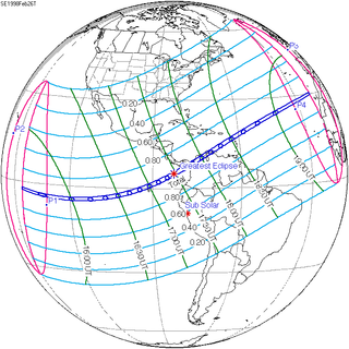
Back Сонечнае зацьменне 26 лютага 1998 года Byelorussian Sonnenfinsternis vom 26. Februar 1998 German Eclipse solar del 26 de febrero de 1998 Spanish خورشیدگرفتگی ۲۶ فوریه ۱۹۹۸ Persian Éclipse solaire du 26 février 1998 French Eclissi solare del 26 febbraio 1998 Italian 1998年2月26日の日食 Japanese 1998년 2월 26일 일식 Korean Zonsverduistering van 26 februari 1998 Dutch Солнечное затмение 26 февраля 1998 года Russian
| Solar eclipse of February 26, 1998 | |
|---|---|
 Total eclipse near Guadeloupe | |
| Type of eclipse | |
| Nature | Total |
| Gamma | 0.2391 |
| Magnitude | 1.0441 |
| Maximum eclipse | |
| Duration | 249 s (4 min 9 s) |
| Coordinates | 4°42′N 82°42′W / 4.7°N 82.7°W |
| Max. width of band | 151 km (94 mi) |
| Times (UTC) | |
| Greatest eclipse | 17:29:27 |
| References | |
| Saros | 130 (51 of 73) |
| Catalog # (SE5000) | 9503 |
A total solar eclipse occurred at the Moon's descending node of orbit on Thursday, February 26, 1998, with a magnitude of 1.0441. A solar eclipse occurs when the Moon passes between Earth and the Sun, thereby totally or partly obscuring the image of the Sun for a viewer on Earth. A total solar eclipse occurs when the Moon's apparent diameter is larger than the Sun's, blocking all direct sunlight, turning day into darkness. Totality occurs in a narrow path across Earth's surface, with the partial solar eclipse visible over a surrounding region thousands of kilometres wide. Totality was visible in the Galápagos Islands, Panama, Colombia, the Paraguaná Peninsula in northwestern Venezuela, all of Aruba, most of Curaçao and the northwestern tip of Bonaire (belonging to Netherlands Antilles which dissolved later), all of Montserrat, Guadeloupe and Antigua and Barbuda.
© MMXXIII Rich X Search. We shall prevail. All rights reserved. Rich X Search
